Geospatial Drone Solutions

Thermal Drone Inspection Services in St. Louis

Radiometric infrared imaging for electrical infrastructure, solar arrays, commercial roofing, and building envelopes across the St. Louis metro, St. Charles County, and Southern Illinois.

What You Receive

Infrared Data That Localizes the Problem

Every object emits infrared energy in proportion to its surface temperature. A thermal drone inspection records that energy as radiometric imagery, in which each pixel carries a measured temperature value, and then interprets the patterns: a connection running hotter than its neighbors, a solar string producing no heat under load, a section of roof holding warmth after sunset because the insulation beneath it is wet.

TerraSight treats thermography as a geospatial product. Thermal frames are georeferenced and, for roofs and arrays, stitched into a thermal orthomosaic that aligns with a matching visual orthomosaic. Anomalies are annotated with coordinates, temperature deltas, and severity so your maintenance team or contractor can walk directly to the finding.

Drone-based capture also removes people from lifts, ladders, and energized areas, and it covers a large roof, substation yard, or solar field far faster than a handheld camera can. Where a site also needs terrain or planimetric data, the same visit can include photogrammetry and orthomosaic mapping.

Standard Deliverables
Radiometric Thermal Imagery (R-JPEG / TIFF) Georeferenced Thermal Orthomosaic Matching Visual (RGB) Orthomosaic Annotated Anomaly Report (PDF) Anomaly Location Map (KMZ / SHP) Temperature Delta Measurements Severity Ranking & Priority List Baseline Set for Future Comparison
Inspection Parameters
Imagery TypeRadiometric Thermal + RGB
CaptureNadir and oblique, georeferenced
TimingScheduled to target conditions
AnalysisThermal analysis software, GIS
Compatible WithArcGIS, QGIS, Google Earth, CMMS
Applications

Four Thermal Inspection Programs

Each application has its own physics, timing, and reporting conventions. We plan the flight and the analysis around the asset, not the other way around.

Electrical Infrastructure Thermography

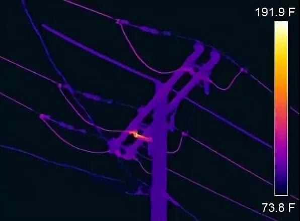
Substations, switchyards, distribution lines, transformers, and outdoor switchgear are inspected under normal load from a safe standoff distance. Thermal imaging reveals loose or corroded connections, unbalanced phases, failing insulators, and overheating components before they fail.

Findings are reported with measured temperature rise over a reference component and ranked for maintenance priority, giving utility and facility electrical teams a defensible basis for scheduling repairs.

Solar Panel & PV Array Inspection

Rooftop and ground-mount solar installations are flown under irradiance with modules producing. Thermal orthomosaics expose hot spots, cracked cells, bypass diode faults, disconnected strings, and soiling or shading losses across the entire array in a single dataset.

Each anomaly is mapped to its module position so O&M crews can locate it in the field, and the baseline supports year-over-year degradation tracking.

Commercial Roof Moisture Surveys

Flat and low-slope commercial roofs are surveyed after sunset, when insulation saturated with water holds heat longer than dry insulation. The resulting thermal pattern shows the extent of wet areas that are invisible from the surface during the day.

Moisture areas are outlined on the orthomosaic and quantified by square footage, which supports targeted repairs instead of full replacement and informs roof warranty and due-diligence decisions.

Building Envelope Assessment

Facades, curtain walls, parapets, and roof-to-wall transitions are imaged when there is a meaningful indoor-outdoor temperature difference. Thermal imagery reveals missing or settled insulation, thermal bridging, air leakage paths, and water intrusion behind cladding.

For multi-story buildings, aerial capture provides consistent coverage of upper floors and roofs that handheld surveys cannot reach safely.

Who It Serves

Asset Owners Across Missouri & Illinois

Utilities & Cooperatives

Routine and condition-based thermography of substations, lines, and switchgear across service territories in eastern Missouri and Southern Illinois.

Solar Developers & O&M Providers

Commissioning, warranty, and annual inspection datasets for commercial rooftop and utility-scale arrays.

Commercial Property Owners & Managers

Roof moisture surveys for warehouses, distribution centers, retail, and office portfolios throughout the St. Louis metro.

Roofing & Envelope Contractors

Third-party thermal data to scope repairs, verify work, and document conditions before and after a project.

Facilities & Plant Engineers

Manufacturing, logistics, and institutional campuses needing electrical and envelope inspections integrated into maintenance planning.

Insurance, Lenders & Due Diligence Teams

Objective, georeferenced condition documentation for acquisitions, claims, and underwriting.

How It Works

Capture. Process. Deliver.

Thermal data is only meaningful when the conditions, the capture, and the analysis are controlled. Our process is built around that.

01
Asset Review & Inspection Plan

We review the asset type, layout, access, and your reporting requirements, then define flight altitude, image overlap, and the environmental window the inspection needs: after-sunset for roofs, load conditions for electrical and solar, temperature differential for envelopes.

02
Scheduling for Conditions

The flight is scheduled around weather, sun angle, wind, and site operations. If conditions on the day will not produce reliable thermal contrast, we reschedule rather than deliver ambiguous data.

03
Thermal & Visual Capture

An FAA Part 107 licensed, professionally trained pilot flies the mission with the thermal and RGB sensors recording together. Radiometric frames are georeferenced, and reference measurements are logged for emissivity and ambient conditions.

04
Analysis & Anomaly Classification

Imagery is processed into thermal and visual orthomosaics, then reviewed frame by frame. Anomalies are measured, classified by type and severity, cross-checked against the visual image to rule out reflections and false positives, and plotted on the site map.

05
Report & Handoff

You receive the annotated report, the georeferenced orthomosaics, the raw radiometric files, and a location file for GIS or maintenance systems. We walk your team through the findings and retain the dataset as a baseline for future comparison.

Why TerraSight

Thermography With Geospatial Discipline

Many thermal flights produce a folder of colorful images and little else. TerraSight produces georeferenced, measurable data: every anomaly has a location, a temperature delta, and a place on a map that matches the rest of your site documentation. That is the difference between an interesting picture and a work order.

We are based in O'Fallon, Missouri, so evening roof surveys, seasonal envelope work, and repeat solar inspections across the St. Louis metro and Metro East are practical to schedule. Our pilots are FAA Part 107 licensed and professionally trained in both flight operations and thermal data interpretation, and our operations are fully insured.

Details on our sensors and processing software are on the technology page. If your site also needs terrain data, our drone LiDAR surveying and topographic mapping services can be combined with a thermal program.

  • Radiometric imagery with per-pixel temperature values, not just false-color stills
  • Thermal and visual orthomosaics aligned for side-by-side review
  • Anomalies located, measured, ranked, and exported for GIS or CMMS
  • Flights scheduled to the conditions each application requires
  • Safer than lifts, ladders, or walking energized yards
  • FAA Part 107 licensed pilots, fully insured operations
  • Baseline datasets retained for repeat inspections and trend analysis
Questions

Thermal Drone Inspection FAQ

What can a thermal drone inspection detect?

Thermal imaging records surface temperature differences. On electrical equipment that reveals overheating connections, overloaded phases, and failing components. On solar arrays it shows hot cells, bypass diode faults, and inactive strings. On roofs and building envelopes it identifies trapped moisture, missing insulation, and air leakage. The camera does not see through materials; it measures what the surface temperature indicates about conditions beneath.

When is the best time to fly a thermal roof or building inspection?

Roof moisture surveys are typically flown after sunset on a clear day, when wet insulation releases stored heat more slowly than dry areas and the contrast is strongest. Building envelope work needs a meaningful indoor-outdoor temperature difference, which makes cold weather ideal. Solar and electrical inspections are flown under load, usually in clear midday conditions. We schedule each job for the conditions that produce reliable data.

Is the thermal data radiometric?

Yes. Our thermal payloads capture radiometric imagery, meaning each pixel stores a temperature value rather than just a color. That allows us to measure temperature deltas, set alarm thresholds, and provide analysts with files they can re-examine in thermal analysis software after delivery.

Do I still need a contractor or engineer after a thermal inspection?

Often, yes. TerraSight delivers the data and an annotated anomaly report that localizes and prioritizes findings. Confirming a suspected leak with a core sample, repairing an electrical connection, or replacing a solar module is work for the appropriate licensed trade or engineer. Our report tells them exactly where to look.

Where do you provide thermal drone inspections?

TerraSight is based in O'Fallon, Missouri and provides thermal and infrared drone inspections throughout the St. Louis metro, St. Charles County, and Southern Illinois, including the Metro East. Larger portfolios and multi-site programs elsewhere in Missouri and Illinois can be scheduled by arrangement.

Related Services

More From the Same Site Visit

Need a Thermal Inspection in the St. Louis Area?
Tell us about the asset and what you need to learn from it. We will recommend the right inspection program.
Request a Consultation