Geospatial Drone Solutions

Mine Site Drone Survey & Exploration Mapping

LiDAR terrain models, pit and stockpile volumes, claim-scale mapping, and reclamation documentation for mining, aggregate, and resource exploration teams, from the St. Louis region to remote sites by arrangement.

What You Receive

Ground Truth for Ground That Is Hard to Reach

Mining and exploration sites share a set of problems: they are large, the terrain is steep or broken, access is limited, and the ground changes constantly. Conventional survey crews cover them slowly and at real risk on highwalls, dumps, and unstable slopes. Satellite imagery covers them easily but at a resolution and currency that cannot support engineering, and it cannot see the ground under vegetation at all.

A mine site drone survey closes that gap. TerraSight flies DJI L-series LiDAR and high-resolution photogrammetry on DJI Enterprise platforms with RTK/PPK positioning and ground control, capturing hundreds of acres a day at centimeter-scale point spacing. LiDAR returns from beneath brush and tree canopy are classified to a true bare-earth surface, so geologists and engineers see structure, outcrop, old workings, and drainage that imagery alone hides. The sensors and processing software behind the work are described on the technology page.

Deliverables are built for the software mining teams already use: LAS/LAZ point clouds, DEMs, contours, orthomosaics, volumetric reports, and 3D mesh models in formats that open in Civil 3D, AutoCAD, ArcGIS, and the major mine planning and geological modeling packages. A capability demonstration from the San Francisco Mining District in Southwest Utah, including a 601-million-point LiDAR cloud you can explore in your browser, is on the projects page.

Standard Deliverables
Classified Point Cloud (LAS / LAZ) Bare-Earth DEM & DSM (GeoTIFF) Contour Map (DWG / SHP) Georeferenced Orthomosaic Pit, Stockpile & Dump Volumetric Report Triangulated Surfaces (DXF / LandXML) Textured 3D Mesh (OBJ / 3D Tiles) Slope & Hillshade Rasters Browser-Based Point Cloud Viewer Accuracy & Control Statement
Survey Parameters
Capture MethodLiDAR, Photogrammetry, or Both
PositioningRTK / PPK with Ground Control
Coordinate SystemState Plane, UTM, or Mine Grid
VegetationMulti-Return LiDAR, Ground Classified
Compatible WithCivil 3D, AutoCAD, ArcGIS, Mine Planning Software
Applications

Four Phases of the Mine Life Cycle

From the first prospect visit to final bond release, the same aircraft and sensors answer different questions. The deliverable set is shaped to the phase.

Exploration & Claim Mapping

For prospects and unpatented or patented claims, a drone LiDAR survey produces a bare-earth terrain model that reveals structure, lineaments, outcrop, historic workings, adits, and dumps that are obscured under vegetation in imagery. Orthomosaics at a few centimeters per pixel document access roads, drill pads, and surface disturbance for permitting.

The dataset gives geologists a georeferenced base for mapping, sampling plans, and drill targeting before a single hole is sited, and a browser-based viewer lets remote team members and investors examine the ground themselves.

Pit & Quarry Progression

Periodic surveys of active pits and quarries produce the current surface, bench and highwall geometry, and the volume mined since the previous survey. Comparison against the mine plan shows where extraction is ahead of or behind design, and slope rasters flag areas where highwall angles have departed from the plan.

Surveys are flown without personnel on benches or below highwalls, and are delivered as surfaces ready for the mine planning package.

Stockpile, Waste & Tailings Volumes

Ore, run-of-mine, product, waste rock, and overburden volumes are computed from the same survey using documented base surfaces, with every pile reported separately. Tailings and impoundment surfaces are measured for freeboard, beach geometry, and stored volume against design.

The method is described in detail on our volumetric measurement page and extends directly to reserve reconciliation and bond estimates.

Reclamation & Environmental Compliance

Regrading, cover placement, final contours, and revegetation are documented on a repeat interval with surfaces and orthomosaics that quantify the extent and progress of each. Erosion, sediment pond capacity, and drainage performance are measured between visits rather than estimated.

The dated record gives the operator's engineer or environmental consultant measured evidence to support inspections, annual reports, and bond release applications.

Who It Serves

Teams That Work the Ground

Mining & Extraction Operators

Surface mines, quarries, and industrial mineral operations needing recurring pit, dump, and stockpile surveys without crews in hazardous areas.

Resource Exploration Companies

Terrain, surface disturbance, and access mapping for claims and prospects, including remote sites reached in a single planned mobilization.

Geologists & Geological Consultants

Bare-earth LiDAR surfaces and high-resolution orthomosaics as a georeferenced base for structural mapping, sampling, and drill targeting.

Mine Engineers & Planners

Surfaces, contours, and volumes in the formats their planning and design software accepts, tied to the mine grid.

Environmental & Compliance Consultants

Measured, dated documentation of disturbance, reclamation progress, and drainage features for permits and reporting.

Reclamation Contractors & Landowners

Regrading quantities, final-contour verification, and revegetation extent to document work completed against the reclamation plan.

How It Works

Capture. Process. Deliver.

Mine and exploration sites reward planning. Remote access, airspace, terrain, and site safety rules are all resolved before the aircraft leaves the ground.

01
Site Review & Mission Plan

We review the claim or site boundary, terrain, vegetation, airspace, and the questions the data must answer, then define point density, flight lines, and the coordinate system. For remote sites, the plan covers access, power, and contingency so one mobilization captures everything.

02
Ground Control & Site Coordination

Ground control points are set with survey GNSS equipment and tied to the mine grid or published datum. On active operations, flights are coordinated with the site safety officer and scheduled around blasting, haul traffic, and shift changes.

03
LiDAR & Imagery Capture

An FAA Part 107 licensed, professionally trained pilot flies the site with DJI Enterprise systems carrying L-series LiDAR and RGB sensors. Terrain-following flight maintains consistent point density across steep ground, and oblique passes capture highwalls and steep faces.

04
Classification, Surfaces & Volumes

The point cloud is processed, checked against control, and classified to separate ground from vegetation, equipment, and structures. Bare-earth DEMs, contours, slope rasters, orthomosaics, and surfaces are generated, and volumes are computed against prior surveys and design.

05
Delivery & Viewer Access

You receive the full deliverable set in your specified formats and coordinate system, with an accuracy and control statement. Large point clouds can be published to a browser-based viewer so geologists, engineers, and stakeholders anywhere can examine the site without specialist software.

Why TerraSight

Demonstrated on a Working Claim

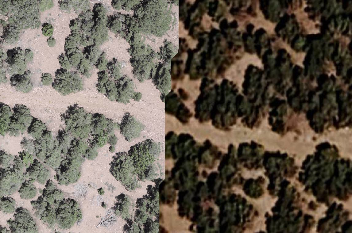
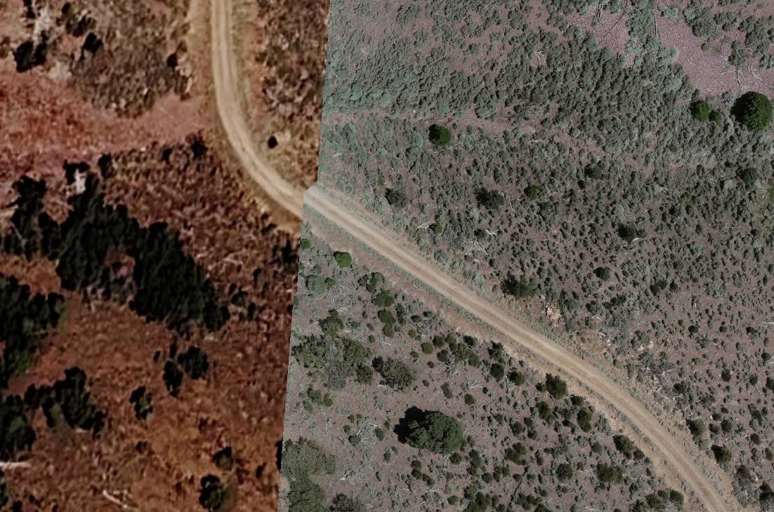
TerraSight conducted a drone survey of the Boulder Reef mining claim in the San Francisco Mining District of Southwest Utah as a capability demonstration. The images below show the same ground captured two ways: standard satellite imagery on one side, TerraSight drone data on the other. Access roads, terrain detail, canopy, and ground surface that are blurred or absent in the satellite view are sharply resolved in the drone data. The full 601-million-point LiDAR cloud of the site is published in an interactive viewer on the projects page and streams in a browser.

That project reflects how we approach mining and exploration work generally: plan a single efficient mobilization, capture LiDAR and imagery together, classify to bare earth, and deliver data that engineers and geologists can measure rather than merely look at. Our pilots are FAA Part 107 licensed and professionally trained in survey-grade data collection, and our operations are fully insured for work on active industrial and remote sites.

We are based in O'Fallon, Missouri, within reach of the quarries and industrial mineral operations of eastern Missouri and Southern Illinois, and we travel to exploration and mine sites elsewhere by arrangement. Related work includes topographic mapping for haul road and facility design and construction monitoring for plant and infrastructure builds. Sensor and software details are on the technology page.

  • Multi-return LiDAR classified to true bare earth beneath vegetation
  • Centimeter-scale point spacing across hundreds of acres per day
  • No personnel on highwalls, dumps, or unstable slopes during survey
  • Surfaces and volumes tied to the mine grid or published datum
  • Formats ready for Civil 3D, ArcGIS, and mine planning software
  • Browser-based viewer for large point clouds shared with remote teams
  • Remote-site mobilization planned to capture everything in one trip
  • FAA Part 107 licensed pilots, fully insured operations
Questions

Mine Site Drone Survey FAQ

Why use drone LiDAR instead of satellite imagery for a mine or exploration site?

Satellite imagery is useful for regional context, but its resolution is measured in meters, it is often months old, and it does not penetrate vegetation to measure the ground. Drone LiDAR captures the site on the day you choose at centimeter-scale point spacing, records returns from beneath tree and brush canopy to produce a true bare-earth surface, and is tied to ground control for survey-grade accuracy. On our projects page, the Boulder Reef comparison shows the same ground captured both ways.

Can you map a site that is far from Missouri?

Yes. Our home service area is the St. Louis region and Southern Illinois, but mining and exploration work is often remote by nature. We have mapped a claim in the San Francisco Mining District of Southwest Utah, and we mobilize to sites elsewhere in the United States by arrangement. Remote-site work is planned so that a single mobilization captures everything the project needs.

How large a site can be surveyed?

Drone LiDAR covers hundreds of acres per day depending on terrain, point density, and airspace, and multi-day campaigns extend that to large claims and mine complexes. The Boulder Reef dataset on our projects page contains 601 million LiDAR points and streams in a browser. We scope flight days and point density to the site and the questions it needs to answer.

Do your deliverables work with mine planning software?

Yes. Point clouds are delivered as LAS or LAZ, surfaces as DEM GeoTIFFs and triangulated surfaces in DXF or LandXML, and contours and features as DWG and shapefiles. These are standard inputs for Civil 3D, ArcGIS, and the major mine planning and geological modeling packages. We can match the project's coordinate system and datum, including local mine grids where control is available.

Can you support reclamation bond release and regulatory reporting?

We provide the surveyed surfaces, orthomosaics, and volume and slope reports that document regraded areas, final contours, cover placement, and revegetation extent over time. Regulatory submittals and professional certifications remain with the operator's engineer or consultant; our data gives them a measured, dated record to build those submittals on.

Related Services

More From the Same Site Visit

Need a Mine or Exploration Site Surveyed?
Tell us about the site, its location, and the questions the data needs to answer. We will propose a capture plan and deliverable set.
Request a Consultation